
A report by United Nations Institute for Training and Reseach (UNITAR) surfaced on April 27th confirmed the heavy use of artillery and aerial bombing of civilian safety zone (CSZ) by the Sri Lankan armed forces. The 10-page document, initially made public, was later blocked by UNITAR for preventing incriminating evidence of Sri Lanka Army (SLA) shelling of civilian areas. Several organizations, including Inner City Press, however, have archived a local copy of the now officially unavailable report.
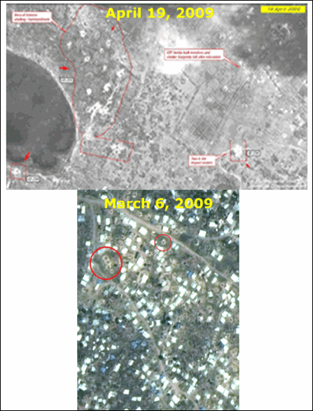
 Comparison of two satellite images of Valaignarmadam on March 29th and April 19th shows a permanent building razed to the ground, and temporary IDP shelters completely destroyed.
Inner City Press raised the issue at UN for not revealing the satellite-based report promptly (see the UN video link 12 minutes from start). Similar analysis was done by UNOSAT, a program within UNITAR, for the conflict in Gaza, and the corresponding report was released promptly.
Sri Lankan conflict, despite unusually large civilan casuality, has been played down at the UN, setting a politically motivated precedent to the Sri Lanka conflict. UN previously kept under closed doors casualty figures in the Safe Zone, until the documents were leaked to Inner City Press.
Modern satellite images have resolutions as small as 0.5 m. The images released in the UNITAR report have been taken by three different satellites which orbit the earth, and can take several weeks to capture a subsequent image of the same geographic location. However, multiple satellites spacially distributed can reduce this time-lag.
Private imaging companies in US have the capability to manuever a satellite to a desired position with short notice for images-on-demand at higher cost. The satellites launched by the US department of defence are known to have much higer resolutions and manuevering capability.
Since satellite images can provide legally admissible evidence for charges of genocide and war-crimes, US-activist groups will likely pursue obtaining such evidence. A spokesperson for one of the groups said, from the archived satellite images a near-ful reconstruction of the impact of shelling inside the safe-zone can be constructed for the period January to April 2009.
External Links:
| |
Time-stamped photographic evidence of the satellite images reveal the level of intensity of shelling carried out by the government forces over the populated areas. The images show impact craters of diameter from 2 to 9 meters spread through out the government designated safe zone as well as adjacent areas where more than 100,000 civilians have sought shelter.

Image of Civilian Safe zone on 19th April
Inner City Press raised the issue at UN for not revealing the satellite-based report promptly (see the UN video link 12 minutes from start). Similar analysis was done by UNOSAT, a program within UNITAR, for the conflict in Gaza, and the corresponding report was released promptly.
Sri Lankan conflict, despite unusually large civilan casuality, has been played down at the UN, setting a politically motivated precedent to the Sri Lanka conflict. UN previously kept under closed doors casualty figures in the Safe Zone, until the documents were leaked to Inner City Press.
Modern satellite images have resolutions as small as 0.5 m. The images released in the UNITAR report have been taken by three different satellites which orbit the earth, and can take several weeks to capture a subsequent image of the same geographic location. However, multiple satellites spacially distributed can reduce this time-lag.

Images of March-April shelling of Civilian Safe Zone (CSZ)
Private imaging companies in US have the capability to manuever a satellite to a desired position with short notice for images-on-demand at higher cost. The satellites launched by the US department of defence are known to have much higer resolutions and manuevering capability.
Since satellite images can provide legally admissible evidence for charges of genocide and war-crimes, US-activist groups will likely pursue obtaining such evidence. A spokesperson for one of the groups said, from the archived satellite images a near-ful reconstruction of the impact of shelling inside the safe-zone can be constructed for the period January to April 2009.
External Links:
| ICP: | Satellite detected damages in Safe Zone | |
| ICP: | Sri Lanka Damage Satellite Photos Withheld by UNITAR |